Posts

Showing posts with the label geology

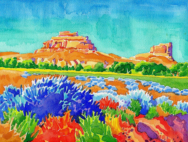
Roxborough State Park - Garden of Providence

Image
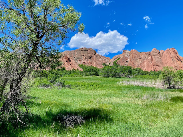
Roxborough State Park Situated at a geological flash point where the prairie meets the mountains, Roxborough State Park is a study in contrast between shapes, textures and colors. Sharing space in this rare environment, smooth, angular, red rocks shoot skyward from out of a bed of broken, nebulous, green scrub-brush. The spectacular esplanade is positioned below the Front Range on a narrow plateau overlooking the South Platte River wetlands. A long string of jagged peaks recedes into the distance and fuses with a solid plate of brilliant, blue sky. During the summer, sweltering heat is stifled by a taut breeze that gusts through a labyrinth of dense woodland, open meadows and vermillion spires. The isolated Eden is unpopulated by human presence and it is mostly deserted except for a plethora of butterflies, a few deer and a pair of hawks circling overhead. The highlight of the preserve is a deep chasm named Fountain Valley where the inspiring views from an overlook are expansive. Once ...

Teton Wildflowers - Watercolor

Image
"Teton Wildflowers" Watercolor During the dead of winter, I start yearning for the sound of birds and the scent of wildflowers. What better way to spend some down time than daydreaming about warmer weather while sketching with brushes and watercolor. The Tetons are an impenetrable domain of jagged alps straddling Wyoming’s western frontier. Filled with flora and fauna, this rugged wilderness erupts with surreal beauty during the fleeting summer. Blue trees cascade down into the forest meadows where fresh prairie grass is dotted with a profusion of Indian paintbrush. Looming above this American Arcadia, the spectacular peaks take on a tinge of pink during the peaceful mornings. The geography is situated at a unique geologic junction. An extraordinary place where the northern plains were folded, buckled and exploded, creating the youngest mountain range in the Rockies. There are no foothills as the outrageously steep pinnacles span over the surrounding landscape. I...

Courthouse and Jail Rocks - Watercolor

Image
Courthouse and Jail Rocks - Watercolor It's a breezy, spring day in Western Nebraska. Courthouse and Jail Rocks tower above the open prairie. A row of stately cottonwoods traces the winding course of Pumpkin Creek while a field of fresh hay slices through rugged pastureland. The fiery foreground is accented by glittering, silver sagebrush. The cloudless sky is a deep blue as the unusual formation appears golden in the evening light and dark shadows define the bold geography. The steep south face is terraced like a Sumerian ziggurat and descends into a labyrinth of mysterious corridors, caves, tunnels and rattlesnake pits. Composed of Brule clay, Gering sandstone and ash, the rocks are erosional remnants of an ancient plateau formed by volcanic activity thousands of years ago. Later, they became an unforgettable natural landmark that guided emigrants during the 19th century's Westward Expansion. Back then, just passing near the monument offered hope to weary pioneers ...

Courthouse and Jail Rocks - Offering Inspiration

Image
Courthouse and Jail Rocks “We came in sight early this morning of the "Courthouse," a hill, or immense mound, which strongly resembles such a building, with wings; it rests imposingly on a bluff; the sides are near a cream color, with apparently, a black roof.” ~ Phillip St. George Cooke (1845) Composed of Brule clay, Gering sandstone and ash, Courthouse and Jail Rocks are erosional remnants of an ancient plateau. They were formed by intense volcanic activity that happened thousands of years ago. The Rocks are located just south of Bridgeport, in the Nebraska panhandle, at the eastern terminus of the Wildcat Hills. The impressive landmark ascends 400 feet above the nearby North Platte River Valley. They’re an enduring symbol of the pioneer spirit, hope and home. During Westward Expansion, they were a famous benchmark as the Pony Express, Oregon, California and Mormon trails all passed by the geographic marvels. The formation was first noted by Robert Stuart, in 1...

San Rafael Swell - An Undiscovered Natural Wonder

Image
The San Rafael Swell “As we approached the river yesterday, the ridges on either side of its banks to the west appeared broken into a thousand forms - columns, shafts, temples, buildings, and ruined cities could be seen, or imagined, from the high points along our route” ~ John Williams Gunnison, 1853 Gunnison had arrived in Mormon Territory, leading a survey team in a futile attempt to chart a route through unforgiving land for the transcontinental railroad. They had followed the Spanish Trail and just crossed the Green River before encountering the remarkable San Rafael Swell. Unable to find a plausible passageway through the maze of cliffs, spires and slot canyons, the dogged crew skirted the barrier and headed west. Soon after leaving the swell, things turned tragic as Gunnison and his group were attacked by Pahvant Indians on 26 October 1853 while camped beside the Sevier River. Gunnison and seven of the eleven men in his party were massacred. Today, the uninhabited reg...

Toadstool Geologic Park, Nebraska

Image
Toadstool Geologic Park, Nebraska Nebraska is known for its flat countryside and endless fields of corn but if you’re willing to veer off the main road and head to the northwest corner, you’ll discover the rugged badlands. It’s a place that time forgot and hiking here is treacherous, tiring and hotter than hell. Just like the red planet, Toadstool Geologic Park is a harsh, sun-baked environment gouged by a desolate chasm. Down at the bottom of the gorge, you’re tempted by a devil's playground of balancing rocks, sandstone spires and a maze of sidetracks. This portal to the center of the earth is an arid landscape that’s awash with spectacular scenery. God may have forsaken this grim abyss long ago but after my remarkable experience here, I’ve come to cherish happy memories of exploring this damned canyon.

Courthouse and Jail Rocks - A Proud Palace of Solitude

Image
Courthouse and Jail House Rocks Located just south of Bridgeport in the panhandle of Nebraska at the eastern terminus of the Wildcat Hills, Courthouse and Jail House Rocks ascend 400 feet above the North Platte River Valley. For me, the rocks are an enduring symbol of the pioneer spirit, hope and home. During the Westward Expansion , they were a famous landmark as the Oregon, California, Mormon, Pony Express and Sidney-Deadwood trails all ran near the geographical marvels. The formation was first noted by Robert Stuart in 1812. From a far distance, he observed a solitary tower rising out of the open prairie. Only upon closer inspection did he discover there were actually two. Stuart thought the larger feature looked like a courthouse, while the smaller a jail. Locals originally began calling the place McFarlan's Castle while passerbys referred to them as the Lonely Tower, the Castle or the Capitol. By 1837, the name Courthouse and Jail Rocks had stuck. During the 19th cent...